From Iguazú Falls to Tierra del Fuego, these Argentina National Parks are wonders of nature. The national parks are a network of 33, each preserving a unique environment and wildlife. Argentine explorer Francisco Moreno donated land in the Andes foothills to create Argentina’s first national park in 1903. Then, in 1934, the National Parks system became official, strengthening the protected areas of Nahuel Huapi National Park and Iguazu National Park.
The National Park Police Force protects these pristine gems. Argentina’s system has different four levels of protection: National Parks, National Monuments, Natural Reserves and Educational Reserves, each with slightly different aims. Many of the parks are UNESCO World Heritage sites also. Here’s our pick of the best Argentina National Parks to visit.
17 Argentina National Parks
The parks represent Argentina’s varied landscape, from rivers and subtropics to deserts to glaciers, mountains and wetlands. Each provides a natural marvel to enjoy, from the vast Yatay palm tree forests in El Palmar National Park to the mighty waterfalls of Iguazú National Park to the plunging canyons of Talampaya National Park. The Glaciers National Park preserves a landscape with several endangered species.
Some national parks are near tourist destinations and easy to access, while others, such as Baritú National Park 350km from Salta, are remote and wild. Many of the parks offer camping opportunities, and some, such as Iguazú National Park, have a range of adventure activities.
Most of the parks offer a Visitor’s Center or Interpretation Center, and some even have museums. National Parks range in size from less than 25,000 ha to over 750,000 ha. While the parks are a nature lover’s paradise, they are well-suited for any explorers and visitors who will be blown away by the natural beauty of Argentina.
Also read:
1- Chaco National Park
Chaco National Park is a 15,000 ha park in the northern Argentine province of Chaco.
The Argentine government formed the park in 1954 to protect the biodiversity in the eastern area of the province, especially the quebracho colorado trees.
Quebracho is a wood that is rich in tannin.
For almost a century, the forests were decimated, almost to extinction due to uncontrolled logging.
Thanks to the creation of the Chaco National Park, the trees are once again thriving.
The park is in a humid region with a subtropical climate and has lagoons, woodlands, savanna, and marshes.
The different types of terrain encourage biodiversity within the park, and the woodlands consist of 15m-high native towering trees. In addition, the lower stratum is covered with chaguares, a variety of bromeliad that has solid and spiky spines.
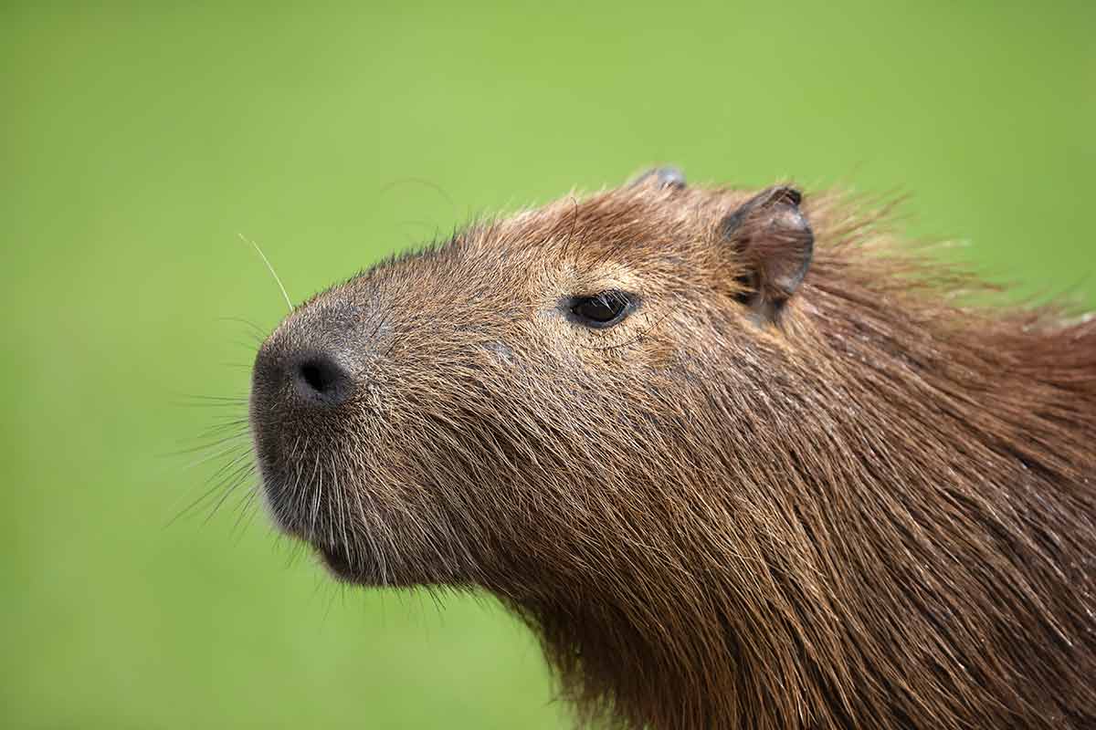
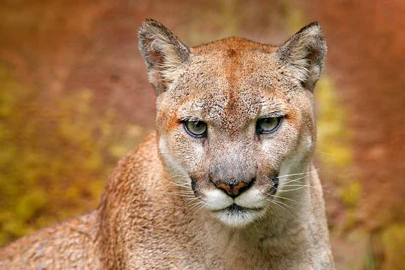
Chaco National Park is a refuge for cougars, caraya monkeys, tapirs, yacarés (a type of alligator), armadillos, capybaras (a kind of rodent) and guazunchos deer. Following rain, you can find the footprints of different large mammals winding through the park.
It is also home to the coralina punteada, a colourful snake that spends a fair amount of time underground.
The lagoons provide a fantastic habitat for the myriad frogs that populate them in the summer, and the marshes are home to the caqueña, an aquatic turtle.
In addition, there are over 340 species of birds in every colour imaginable.
The park has a decent camping zone, with bathrooms, tables, drinkable water, and light. Several footpaths branch off from the camping area, making it very easy to explore. In addition, multiple campsites without bathrooms and electricity exist near the Panza de Cabra Lake, offering a more natural experience.
Tobas and Mocovíes, descendants of the first known indigenous communities in this area, live near the park.
You can drive through the park along the main path. There are two pedestrian crossings from the main road: one 3 km path that takes hikers to two smaller lakes, with excellent birdwatching lookout points. The other is 1.5 km long and starts near the campgrounds.
2- El Palmar National Park
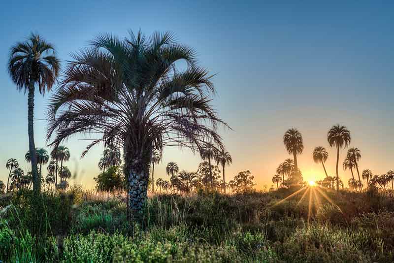
El Palmar National Park is in the province of Entre Rios, in the Littoral region of Argentina and covers 8,500 hectares.
It was established in 1965 to protect a representative sample of the largest yatay palm tree concentration in all of Argentina.
Yatay palm trees are known for their sweet orange fruit and vibrant yellow flowers, which bloom in dense bunches. The yatay palm tree used to populate three different provinces, including Entre Ríos, densely but has thinned out over time due to farming.
The national park was once home to many indigenous settlements.
In later years, between 1650 and 1767, the official Entre Ríos fields protector, Barquín, developed a successful lime factory. Today, the ruins of the factory remain a significant historical site.
Entre Ríos is part of the Mesopotamia zone of Argentina and has an ethereal landscape and weather that changes by location. For example, it can be hot and wet in the north while remaining mild and dry in the southeast.
The Uruguay River borders the eastern edge of the park, with brooks and streams running throughout the park, nourishing the diverse flora and fauna.
The park has several different environments, including palm forests, pasture lands, and groves, interspersed with grasslands and areas of bank jungle along the river.
The bank jungle is dense and rich with mataojos, trees from the myrtle family, and the guayaba colorado.
Between the bank jungles and the pastures is an irregular line of forests inhabited by the cacholote castaño bird, known for its large and complex nests.
The wide variety of birds throughout the park includes the carpenter bird, the ñandu, and the South American partridge.
Overos lizards, which can sometimes (though rarely) grow up to 1.5 m in length sun themselves in the park.
At night, it’s common to see vizcachas, a type of rodent closely related to the chinchilla, known for its distinct moustache-like markings and vocal calls.
The park is also home to a few exotic species that present a problem to the native flora and fauna, such as the European wild boar (which destroys birds’ nests) and the paradise tree.
There is a 12 km path from the main road on the west edge of the park that ends at the administrative centre on the east side, near the Uruguay River and the main camping zones.
The camping zones are also home to a general store, grills, tables, warm water, shops, public telephones, and bicycle services.
The Visitor’s Center provides guests with an exhibition about the national park’s history, nature and values, which are all an essential part of appreciating the park’s beauty.
Four main pedestrian paths throughout the park cross through various environments, and there are four internal vehicle paths. The main driving path connects the Barquín ruins and the Uruguay River beaches.
The park’s highlight is its three panoramic viewpoints throughout the park, from which you can truly admire the vastness of the area.
3- Formosa Natural Reserve
In Formosa in northern Argentina lies the Formosa Natural Reserve, created for the protection of a representative sample of eastern Chaco in 1968.
The protected area includes 10,000 ha of “dry Chaco” eco-region, with a warm climate and the highest temperatures on the continent. In summer, it rains regularly (between 500 and 700 millimetres).
The Teuco river borders the southern edge of the park, and the Riacho Teuquito, smaller but just as beautiful, runs along the northern boundary.
Along the banks of both rivers grows a dense scrubland, with a diversity of flowers and other plants.
The country’s only protected area of Palo Santo trees is within the Formosa Natural Reserve, in the flatlands between the two rivers.
This tree is desirable for its green, aromatic wood. Because of this, it is an endangered plant in many other parts of the country, but this reserve provides the needed protection to keep the species alive.
The sparse understory includes plants such as ucle and cardoon cacti. In addition, the floodable areas of the reserve are home to different beautiful trees, such as the native willow and tessaria.
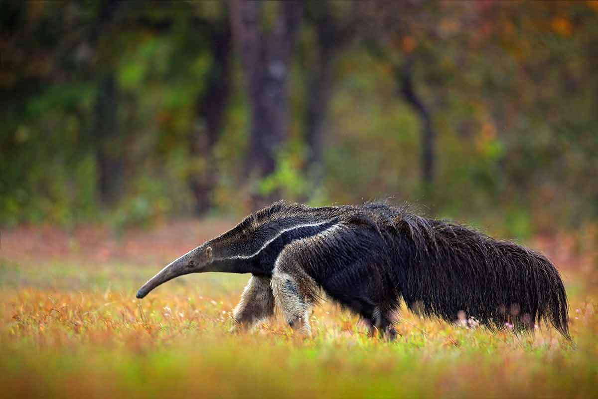
The fauna of the region of Argentina is just as fascinating as the flora, with the main mammal being the giant anteater. These species desperately need the refuge offered by the reserve. Other animals that thrive here are the guazuncho or corzuela parda, which can both be easy to spot.
There is also a diversity of colourful birds, including the turquoise-breasted parrot, a popular pet; this reserve protects poachers who collect the chicks to sell.
Chachalacas and the white-breasted woodpecker are also common sightings.
The area is also home to the slow-moving chameleon, with its independently movable bulging eyes, long slender tongue and grasping tail. Ducks, herons, bats and dozens of other species also call the reserve home.
There is a designated camping zone with bathrooms and a 6,000 m-long path called Monte Adentro, from which you can view a variety of plants and animals. Rangers are on-site to answer questions.
Formosa Natural Reserve is remote; the nearest town is Ingeniero Juárez, 65 km away. The reserve sits between the villages of El Yacaré and La Florencia. It can be accessed from either Ingeniero Juárez or Formosa City, on routes 81 and 39.
4- Huemul National Park
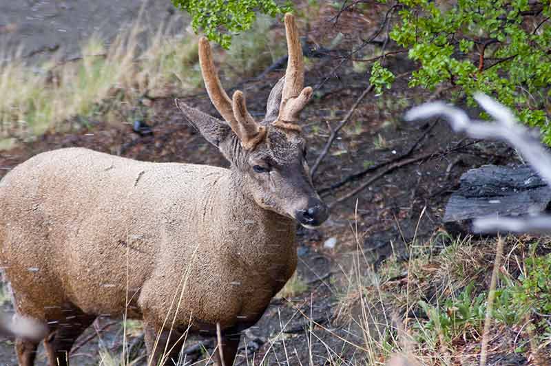
Stretching over an extended area of southwest Argentina lies the Huemul Natural Monument, created in 1996 to protect the Huemul deer.
The Huemul is a critically endangered deer native to the Patagonian forests in Argentina and Chile, with under 1000 of its kind left in the world.
Several factors have contributed to the significant decline in population, including overhunting, the introduction of red deer and domesticated animals, disease from livestock, habitat loss from erosion and fires, and attacks by domestic dogs.
Huemul either live alone or in groups of up to 10 animals. In the summer, they climb the rocky terrain to stay cool at a higher altitude, while in the winter, the deer migrates back down to the wooded valleys.
You can spot a Huemul by its large ears, brownish-grey coat, white underbelly and bright eyes. Males have simple, forked antlers, which they shed in the winter and re-grow every spring.
This beautiful South Andean deer eats plants and shrubs and loves places with fresh water.
The deer once populated the south of Mendoza, Neuquén, Rio Negro, Chubut and Santa Cruz. But these days, they are limited to subantarctic forests with difficult access, from the south of Neuquén (Nahuel Huapi National Park) to the province of Santa Cruz (Los Glaciares National Park).
The Huemul is protected in several national parks, including the Nahuel Huapi, Los Alerces, Lago Puelo, Perito Moreno, and Los Glaciares.
5- Iguazú National Park
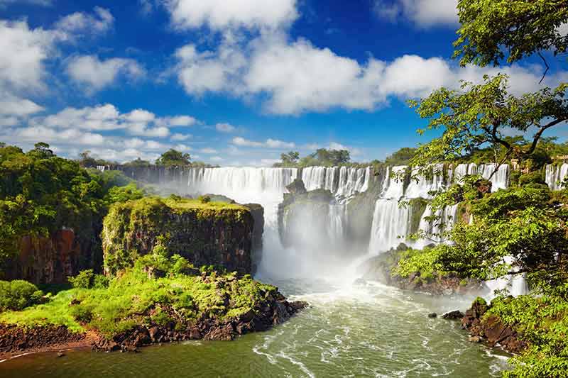
In Misiones in northeast Argentina lies one of Argentina’s most beautiful national parks, home to one of South America’s most famous natural wonders, Iguazú Falls.
Iguazú National Park covers about 550-square-km from Argentina to Brazil and is a mix of subtropical jungles, rivers, and waterfalls.
Authorities created this national park in 1934 to conserve one of the country’s most beautiful natural spots along with the flora, fauna, and waterfalls found there.
Separating the Argentine park from the Brazilian park is the fast and furious Iguazú River, a river that at times spreads up to an incredible 1,500 m wide, flows further than 1320km in total, and finally, 23km ahead, ends up in the Parana River.
This spectacular national park was announced as a World Heritage Site by UNESCO in 1984.
One of the reasons to visit Iguazú National Park is to see the spectacular natural wonder, Iguazu Falls. This enormous group of waterfalls consists of more than 275 falls, some of which reach up to more than 80 m high, stretching more than 2.7km along the Iguazú River.
The world’s most extensive collection of waterfalls is a wonder to see from both Argentina and Brazil.
Iguazú’s subtropical jungle consists of various trees, some growing higher than 40m, such as the Curupy tree (which grows near the edge of the river), the Aguay, and the Ceibo, whose flower has been declared the national Argentine Flower.
Orchids grow in these forests, attaching themselves to the limbs of trees, absorbing the moisture and nutrients, and, at a lower level, yerba mate, one of Argentina’s favourite herbs to make tea.
Most of the soil found in the national park is red, moist, and full of nutrients, which is a significant reason why vegetation is so dense. In addition, the high temperatures and humidity create a natural greenhouse, giving the vegetation precisely what it needs to grow all year round.
Iguazú national park is home to more than 400 species of bird, insects and bugs, hundreds of animal species, a few sadly on the list of extinction.
Although wildlife is not easy to spot, it’s possible to sight pumas, jaguars, small mammals, reptiles, anteaters, snakes and a diversity of butterflies.
Birds are a whole different matter, literally filling the jungle, and it’s incredible to see such a diverse range of species such as toucans, eagles, parrots, and parakeets.
Take a bus from Buenos Aires (18 hours) or fly. The national park has hundreds of hiking trails, boat rides, guided tours to see the waterfalls, and adventure sports like canopy rides or river dives.
6- Lago Puelo National Park
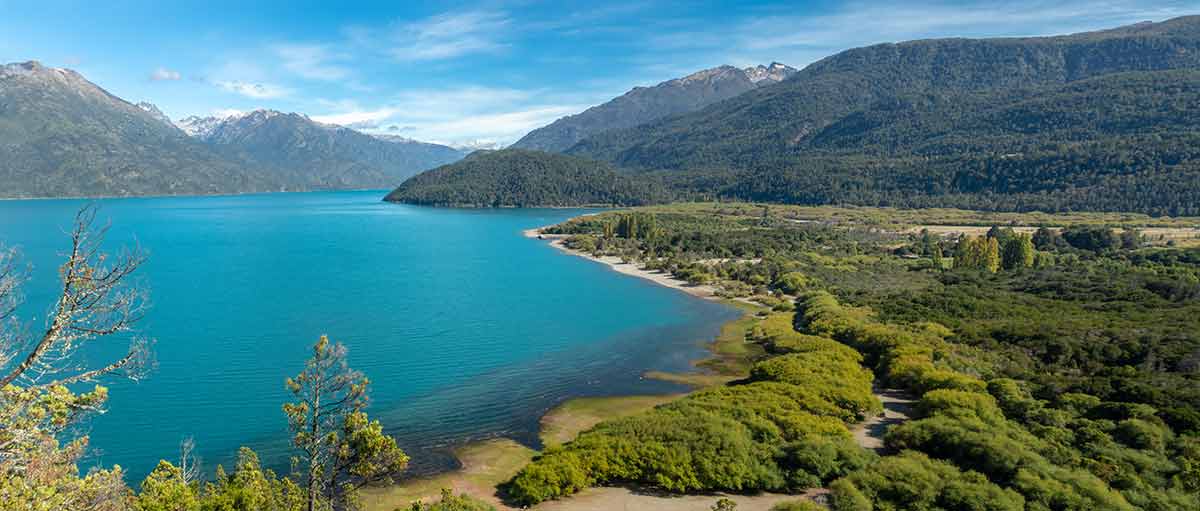
Lago Puelo National Park is a smaller, though no less beautiful, parks in Argentina’s network of 29 magnificent parks.
Its 276 sq km sit in the northwest of the Chubut province, in the heart of Patagonia.
The park is relatively young, created in 1971 to protect the beautiful landscape and Valdivian flora contained within.
Puelo Lake is the main lake in the park and has a gorgeous bluish-green colour due to the high levels of glacier sediment, or silt, within the regional rivers.
The park consists of many eco-regions, including the Patagonian forest, steppes and the High Andes.
The climate is generally cold and wet, and it snows in winter. Being a part of the Andes means it’s mountainous and glacier action in the area has created many lakes and rivers.
Some of the flora within the park, such as the Avellano, tique, lingue and ulmo, are part of the Valdivian rain forest ecosystem that is unique to this part of the world.
Wildlife in the park is well protected, including pudu, huemul, red fox and cougar. There are over 100 species of birds, and the lake is brimming with various fish, including many trout species.
The first settlers to this area were hunter-gatherers and used stone tools for hunting the native guanacos.
Many of the caves within the park contain cave paintings with maps and paths through the forest.
You can find Mapuche villages and communities in the eastern part of the reserve.
The park has a variety of activities, such as swimming, catamaran sailing, hiking, boating and guided horseback riding. There is a camping area, and plenty of on-site information for visitors.
7- Lanin National Park
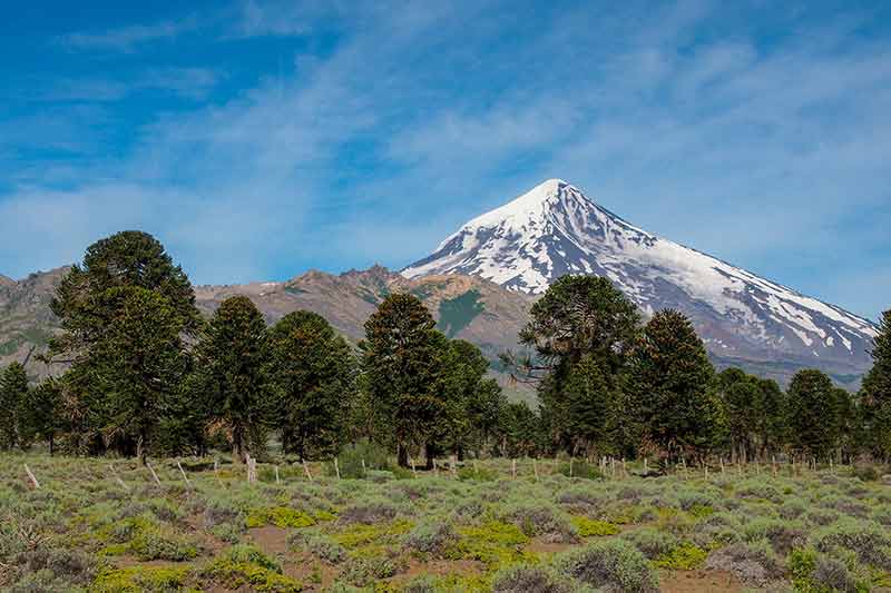
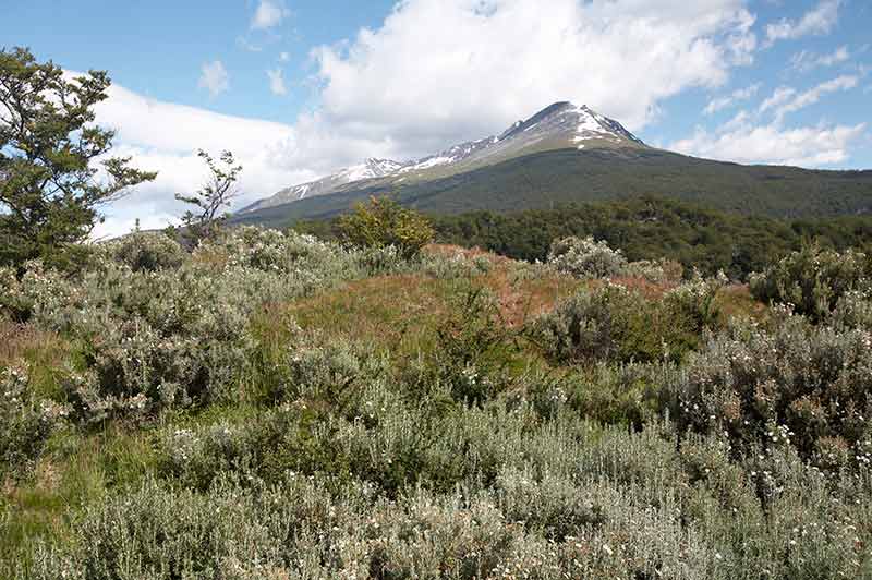
Located in the province of Neuquén, in Patagonia, Lanín National Park was created in 1937 to protect its unique ecosystems, landscapes and species.
The park is bordered on the west by Chile and to the south by Nahuel Huapi National Park.
The park’s topography is beautiful and interesting, transitioning seamlessly from the majestic Andes to smaller, rolling hills.
Exclusive to the southern Andes Cordillera, the park is home to a large lake basin of 24 sparkling glacial lakes framed by several mountain ranges in the distance.
The Lanín volcano (3,776 m) towers 1,500 m above the surrounding mountains, making it the focal point from every angle and its magnificent peak is accentuated by its permanent snow covering.
The park’s landscape includes a variety of forests unique to the Patagonia and the Andean region. On the northern end of the park, you can explore pehuén forests, a type of pine also known as araucaria, or monkey-puzzle tree that grows up to 45 m tall.
As expected, its seeds provide nourishment to the area’s animals, but they are also a source of nutrition for the Mapuches and other local inhabitants, even today.
Other types of forests are the roble pellín, which often grows with the raulí, and they are both found in the north and southwest areas of the park.
The park’s 1,500 mm of rain per year provides a perfect environment for the Valdivian forests, made of spectacular coihue.
The park is full of thriving animals of all kinds, such as the pudú, which is the world’s smallest species of deer, and a variety of other mammals, beautiful soaring birds, and diverse insects.
It’s best to hike the more challenging circuits with a park administration guide. The Tromen area sits at the foot of the volcano and will find most of the challenging treks there.
Other areas include the Villa Quila Quina area, with trails to the carbonated mineral water spring and the Arroyo Grande rapids. The Huechulafquen area has both hiking trails and climbing trails, all of which vary in difficulty. The Lácar – Queñi area has a shorter, 4 km trail that leads you to a campsite with nautical sports facilities, another great way to enjoy the park.
San Martín de Los Andes is the nearest city. There are campgrounds within the park, some with facilities and others are basic.
8- Los Alerces National Park
Los Alerces National Park is in the Patagonian province of Chubut and has been a protected area since 1937.
The park is 2,630 sqkm and runs along the Chilean border.
Los Alerces was created to protect the alerce forest and other types of Patagonian Andean flora. The alerce tree is one of the world’s most ancient trees with one of the longest life spans.
Some of the trees within the park are about 3,000 years old, and many are well over 1,000 years old. The tree grows slowly and is part of the Cupressaceae family.
As the park is quite large, it has several forests and two different climates.
The west is home to a Neotropic ecozone of Valdivian temperate rain forests, which experience high rainfall and sit below the towering Andes mountains.
The remainder of the park consists mainly of Patagonian forests, with lenga trees, similar to Lanín and Nahuel Huapi National Parks.
The park is also home to a complex lake system connected by winding rivers like the Frey River and the Menendez, Rivadavia, Krüger and Futalaufquen lakes.
Lake Amutui Quimei is an artificial lake created to serve as a hydroelectric dam to provide energy to Puerto Madryn.
There are many different ways for visitors to enjoy this magnificent part of the country. Of course, hiking is an obvious choice, and there are many paths to enjoy.
The park’s primary forest is at Puerto Sagrario, which sits at the northern end of Lake Menendez. The Arrayanes river also runs through the area and is lined with arrayán trees.
Another popular choice for exploring the 20-some different trails is on horseback or mountain bike. These trails will even take you to see prehistoric stone paintings, as well as the native plants, flowers, and fauna that populate the area.
The park’s headquarters is a great place to start your visit and are on the shore of Lake Futalaufquen, where there is also a small settlement.
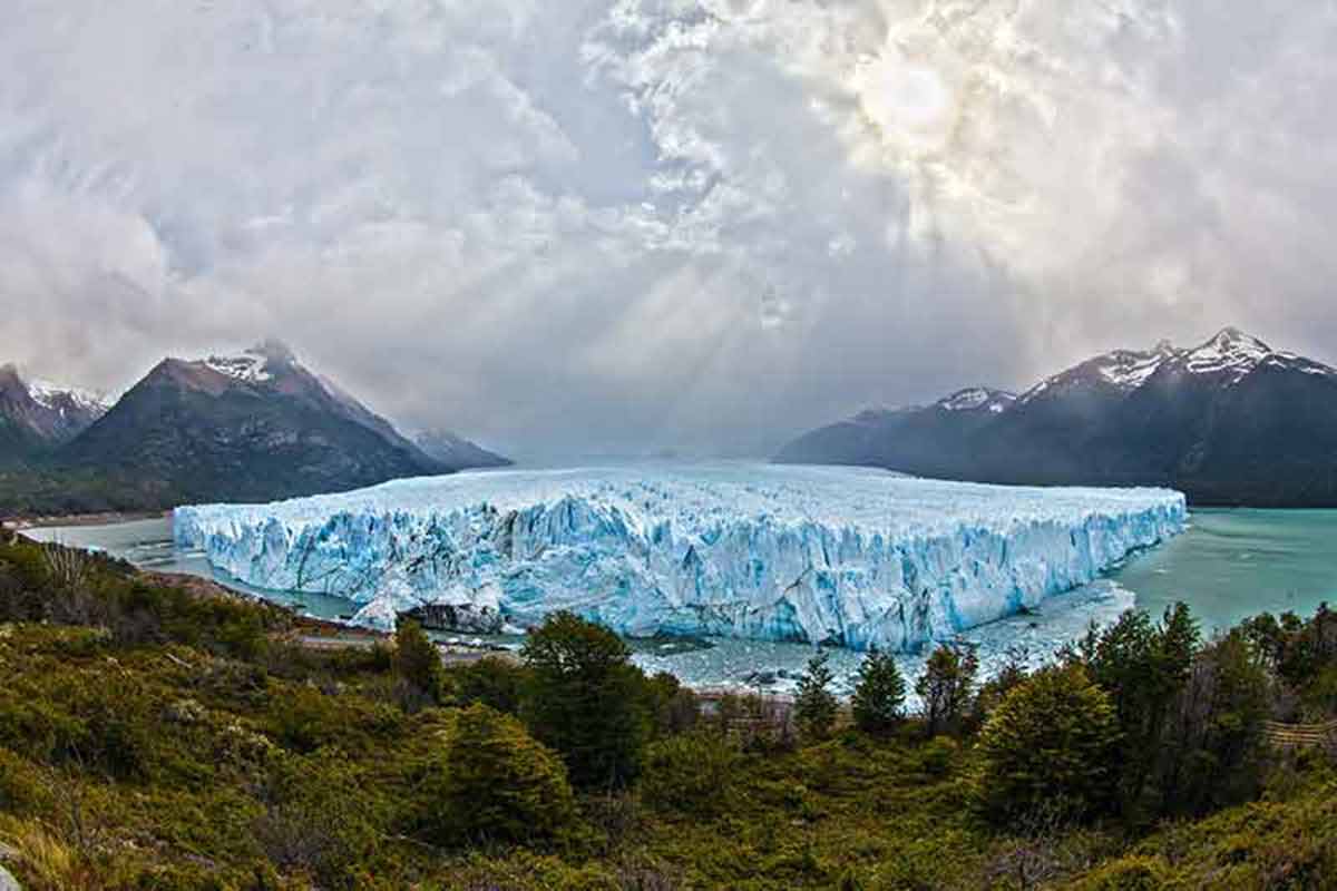
9- Los Glaciares National Park
Los Glaciares National Park is a World Heritage Site on the southwest edge of the province of Santa Cruz and is a breathtaking national park with mountains, lakes and forests, from the icy Andes to the Patagonian steppe.
Los Glaciares is a wonderland of glaciers and ice. The glaciers are formed from Patagonic Continental Ice, the world’s largest continental ice extension after Antarctica.
The park consists of 47 impressive enormous glaciers, 13 of which flow to the Atlantic Ocean. There are over 200 smaller glaciers, as well.
What’s unusual about these glaciers is they start at 1500m above sea level (which is lower than most glaciers that are 2,500 m above sea level) and descend to 200 m.
Two large lakes, Lago Argentino and Lago Viedma flow via the Santa Cruz River into the Atlantic Ocean.
The most well-known part of the park is Perito Moreno, a massive glacier in the park’s south.
This glacier constantly moves, cyclically advancing and retreating, with spontaneous outbursts and ruptures due to the glacier advancing to one end of Lago Argentino, creating a natural dam against the water.
The water can rise to 30 m, and as it has nowhere else to go, it creates pressure on the glacier, which eventually ruptures, and the cycle begins all over again.
This irregular cycle is a naturally occurring event, taking place since 1917. It ruptures between one to 10 years, but the average tends to be every four to five years.
The glacier is a massive 5 km wide, with an average height of 75 m above the water’s surface. True to the “tip of the iceberg” cliché, the total ice depth is 170 meters. It is one of three Patagonian glaciers that are currently not retreating.
While the entire park has so much to offer in terms of beauty and adventure, Perito Moreno is undoubtedly one of the top attractions. It’s about two hours by bus from El Calafate, and there are many tour companies to choose from.
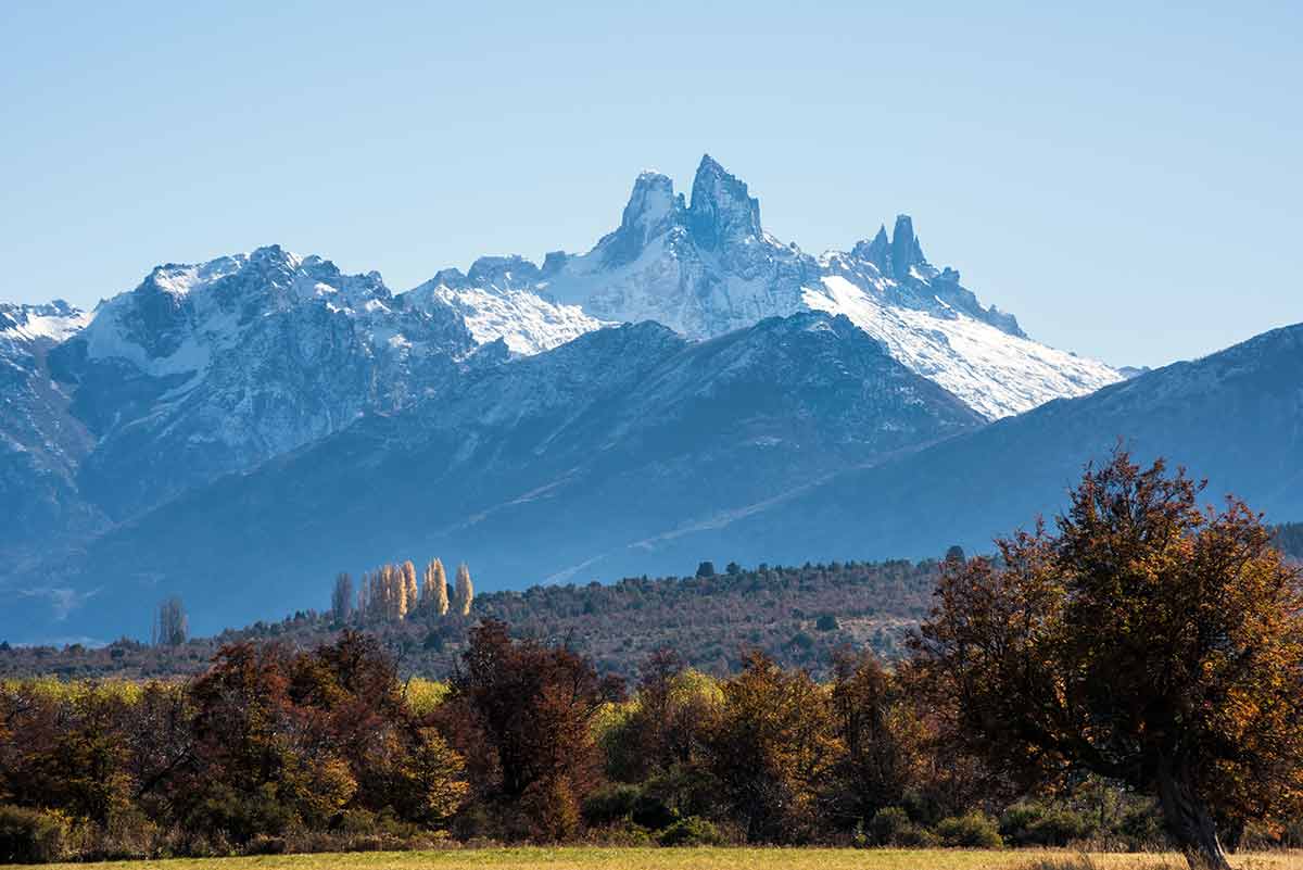
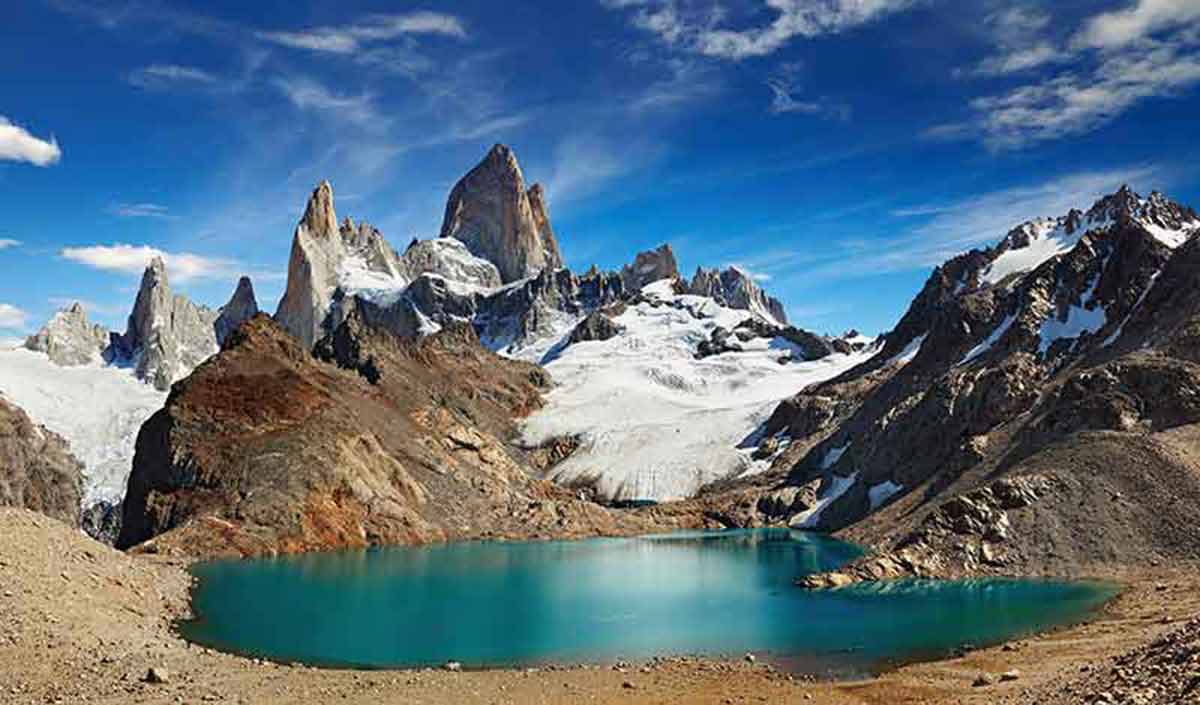
On the other side of the park is Mount Fitz Roy and where you will find the highest, most impressive peaks, with beautifully diverse forms of mountain granite.
Mount Fitz Roy and Mount Chalten are 3,405 m. The hub for this area is El Chalten, a small town that attracts many climbers and trekking enthusiasts.
The park is home to condors, eagles, pumas and the Patagonian guanaco.
Arrive from El Calafate, by bus or car. El Calafate is easily accessible by land or air. Activities and tours are available nearly year-round.
10- Mburucuya National Park
Mburucuya National Park is 17,660 ha, and due to the region’s sub-tropical climate, the diversity of plants here is astounding.
The noisy squawks of the forest are a testament to the 150 different species of birds that inhabit the park, including woodpeckers, parrots and various birds of prey.
Mburucuya National Park’s land was donated in 1991 by Doctor Troels M. Pedersen and his wife, Nina Johanne Sinding. It was officially opened by the government to the public in 1995, during the presidency of Carlos Menem.
The land was passed onto Doctor Troels M. Pedersen by his father, Dr. Nils Peter Pederson, a Dane who had acquired the land in 1928. The doctor was a botanist who immediately set about researching, investigating and studying flora and fauna in the area.
Conservation and environmentalism were high on his agenda, for example, Pederson prohibited hunting here, hence the excellent condition and incredible biodiversity that the park continues to enjoy today.
The park’s landscape is mostly wetland, and the area has 111 lakes and a network of rivers that is crucial in balancing the water and ecological systems in the local area.
Dryland here is sparse, and the park is mostly made up of tiny islands. These islands and network of waterways house some remarkable creatures.
Visitors to the park will hopefully get a glimpse of the brown howler monkeys, otters, marsh deer, jaguars, foxes, pumas, cayman and alligators that all inhabit the area.
Mburucuya National Park is only 150 km from the capital of the province of Corrientes and can be visited as a day trip. The park has a visitor’s centre, public toilets and drinking water fountains.
There are two separate paths that you can use to explore the park; the “Yatay” ends at a swampy lagoon while “Cheroga” is longer through the park’s Lakeland and rainforest environment.
You may also like:
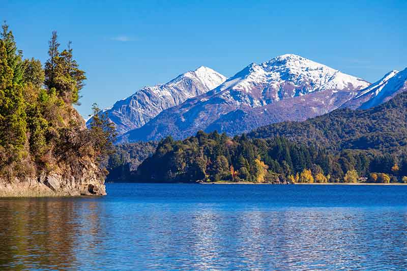
11- Nahuel Huapi National Park
Nahuel Huapi National Park is Argentina’s oldest national park and has been part of the national park system since 1934.
The land in the centre of the park was donated in 1903 to the federal government by Perito Moreno.
The park sits at the foothills of the Andes, deep in the heart of Patagonia and its 7,050 sqkm straddles the southwest of Neuquén province and the northwest of Río Negro province.
Chile borders the park to the west, and San Carlos de Bariloche, the largest city within the park, is a popular tourist destination year-round.
Apart from its rich history, this park is fascinating because it is home to another park.
Los Arrayanes National Park sits on the Quetrihué Peninsula in Nahuel Huapi Lake, protecting the unique arrayanes myrtle trees.
This area is full of lakes and is popularly known as the Argentine Lake District, which consists of many lakes, including Mascardi Lake, Guitérrez Lake, Moreno Lak, Guillermo Traful Lake, and Nahuel Huapi Lake.
The latter has many islands, including Isla Huemul, where Argentina conducted secret research on nuclear fusion from 1949 to 1952.
Cerro Catedral is one of the most famous mountains in the park and is home to a popular ski resort.
The park’s highest peak is Cerro Tronador, which is right on the border with Chile, and stands 3,491 m.
The park’s rich flora and fauna are what make the park so famous, and each year, thousands come to hike and explore its diverse and beautiful landscapes.
As it has a range of altitudes from 700 to 3,000 m, and everything from 4,000 mm a year rain in its western rainforests to 300 mm a year rain in its eastern steppes, there’s a wide range of flora and fauna.
From alerce, a slow-growing conifer, to the unique arrayanes mentioned above, and continues, ferns, lengas, ñires, and amencayes. Llao llao is a fungus that grows as beautifully interesting irregular growths on local trees, and is symbolic of the area.
Wildlife found in this park includes river otters, huemuls, guanacos, maras, parakeets and soaring condors. Guanacos are unique, small llama-like animals found only in Patagonia.
The area is one of the most beautiful and most famous in the country and is bordered by Lanín National Park.
12- NM Ballena Franca Austral
After being widely hunted for nearly 300 years, the Southern Right Whale finally received international protection in 1937 by the International Whaling Committee.
Since then, the population of this once-endangered animal has been on the upswing, helped by creating Argentina’s National Monument of the Southern Right Whale in 1984.
Southern Right Whales are baleen whales with a bow-shaped lower jaw, and their heads are up to a quarter of the 15-meter body length. They are skimmers, with filters in their mouths that allow krill, their primary food source, into their mouths as they slowly swim. Occasionally, they are also bottom-feeders, eating from the mud on the ocean floor.
Right Whales were named so because whalers considered them to be the “right” whales to hunt: rich in blubber, slow swimmers (making them easy to catch), and they float when they are killed.
Today, this species is thriving and can be seen during certain times of the year off the Peninsula Valdés, on the Patagonian coast.
Around the end of April, 450 to 600 whales arrive in the San José Gulf and Nuevo Gulf, looking for shallower water to give birth.
They stay the winter and part of the spring, then travel south for deeper waters for their summer feeding.
The average gestation period for the Southern Right Whale is 12 months, and newborns are around five to six metres long and can swim within the first 30 minutes of life.
About 200 whales are born each year, between July and October, and they are nursed for about one year.
The closest city to seeing these majestic creatures is Puerto Madryn. From there, on Doradillo Beach, you can see the whales off the coast.
In Argentina, the entire Southern Right Whale species is considered a National Monument, granting the whale absolute protection.
In addition, different provinces have taken further measures for greater protection; the Chubut province has signed various local legislations to help protect the whale.
13- Perito Moreno National Park
Perito Moreno National Park was created in 1937 to protect the region’s richness, which includes lenga (a type of beech) forests, two-lake systems, Patagonian steppe areas, fossils, and a wide range variety of wildlife.
The national park covers 115,000 ha with mountain chains cut by valleys, many of which are 900 m above sea level.
Hills and mountains surround the park on every side, creating an incredible natural amphitheatre.
The weather is consistently cold, with permanent snows and an average of 100 to 200 mm of rain annually.
The park lies on the westernmost edge of the country, in the northwest of the province of Santa Cruz.
There are three distinct environments in the park: The Patagonian steppe, a transition area, and the forest.
The forest consists almost entirely of lengas and is mainly in the coastal zones of the Azara and Nansen lakes.
The park has a high scientific and cultural value, thanks to the paleontological remains and biological elements that it protects.
9000 years ago, the area was inhabited by hunter-gatherers, who moved between the steppe and the forest.
The original inhabitants lived in caves tucked throughout the area but later moved to open-sky awnings. Special activities, like leather making and dyeing, however, were still done in rocky eaves.
According to archaeologists, the park was abandoned in the 18th century due to the ice age.
The guanaco, a relative of the llama, was one of their main animal resources used for meat, bones, leather, tendons and veins.
These days, guanaco freely roam the park. The national park also protects the huemul, a type of deer unique to Patagonia, that is dangerously close to extinction.
The largest predators in the region are the puma and the red and grey wolf.
The many small, beautiful lakes fed by thawed snow provide a habitat for various aquatic birds, including flamingos, hualas, black-necked swans, and various ducks.
Andean condors, the black and white hawk-eagle, and many other great birds call the park their home, as well.
Although many other lakes in Patagonia have various exotic fish, the lakes in Perito Moreno National Park are only full of native fish.
Bring extra fuel when visiting the park as the nearest gas station is in Gobernador Gregores, about 200 km away.
There is also no organised campsite. However, the comprehensive Park Information Center can provide information on the different routes.
The Alero, near the Park Information Center, has cave paintings and 6000-year-old archaeological ruins, a must-see when visiting this area.
Traces of settlers from years past can also be seen on many of the various hikes.
14- Ischigualasto Provincial Park (Valley of the Moon)
Ischigualasto Park was officially created in 1971, covers a large area of 63,000 ha and is in the Northeast of San Juan province.
This region is commonly known as ‘Valle de la Luna,’ which translates in English as Valley of the Moon, and it certainly deserves such a title.
This place is out of this world; you feel like you’re walking on the moon, just with more gravity.
The name comes from the unusual formations of rock that characterize this canyon.
The Valley of the Moon boasts multicoloured rock stripped in red, brown, black and grey, as well as tall towers of sedimentary rock that have been formed by vicious sandstorms and ancient waterways that used to cover the valley.
The arid, desert climate means that you won’t have to go far to spot a cactus and all the vegetation in the area has tiny leaves to prevent evaporation by the hot temperatures.
It’s worth taking your binoculars along to spot some of the wildlife, such as condor eagles, desert foxes, pumas, alpacas and lizards, snakes and a variety of insects.
The park is a protected area, and the rules and regulations here are strict.
Visitors can explore the park by car, accompanied by a specialist guide at all times.
The circuit around the park covers 40 km and is designed to show off Ischigualasto’s highlights.
The park also provides other types of activities, such as nocturnal explorations during a full moon.
15- San Guillermo National Park
One of the newer national parks is San Guillermo National Park, in the province of San Juan, established in 1998.
San Guillermo offers protection to the largest concentration of camelídos, or camelids, in all of Argentina.
The camelids family includes camels and Argentinean camelids include the guanaco and the vicuña.
The guanaco is protected in several other national parks, however, the conditions of this park allow it and the vicuña to reach a very healthy level of population growth.
Other animals in the park include cougars, condors, red foxes and two types of small lizards.
The area is split into two sections, the Provincial Reserve and the National Park covering over a million hectares of land.
The park is not green or lush, as the vegetation must withstand the very low winter temperatures and the high altitude.
There is low annual rainfall, but the winters often bring heavy snowfall, and wind gusts can reach 100 km per hour.
Access is only available by 4WD and while the park is open year-round, it is only advisable to visit from September to March.
There are two roads in; one from Rodeo, which is more difficult to travel, and the more popular road via La Rioja.
No other national park on earth has such a density of vicuña. These dainty camels’ and llamas’ relatives are beautifully agile, with charming large eyes and soft, fine wool.
16- Sierra de las Quijadas National Park
Sierra de las Quijadas is a National Park, a Provincial Park and National Reserve in the province of San Luis.
Authorities created the national park in 1991 to conserve the Dry Chaco and Monte regions’ environments and preserve its archeological and paleontological sites.
This area is the driest in Argentina, and the vegetation changes throughout the park, becoming less diverse in the south as the cacti and carob trees disappear.
The park is 150,000 ha and has rich colours and exotic formations.
The intriguing sierras result from the elevation of conjoined layers produced millions of years ago, combined with the local winds, which have created valleys and gorges that reveal different colours and unique shapes.
A fascinating sample of this natural process is Potrero de la Aguada, a succession of grades and cutouts.
Plants include cacti and trees that grow well in dry ground.
The park is home to species in danger of extinction, such as the mountain lion, puma and guanaco.
There is also a vibrant birdlife including falcons, condors, ñandús, yellow cardinals, black-neck swans and red eagles.
Sierra de las Quijadas National Park also strives to conserve the fossil remains of the little-known prehistoric animals that once roamed these lands.
There are also archeological sites of indigenous cultures, such as Los Hornillos, part of the Huarpe culture.
Several different routes can be walked once in the park, lasting from one to five hours. There is also a self-guided plant life tour, which can help you better get to know the stunning surroundings.
Visitors can access the park from the city of San Luis along RN 147.
17- Tierra del Fuego National Park
Located at the end of the world, protecting the sheer beauty and magnificent landscapes, Tierra del Fuego National Park was created in 1960.
This 63,000 ha is a wonderful place to explore the Andean-Patagonian forest.
The area is a large island that straddles Argentina and Chile.
The two great bays are lined with small beaches, while the beautiful backdrop of rugged mountains and valleys is sculpted by glacial erosion.
The park sits at the southernmost tip of the South American continent, reaching over the Chilean border.
There are two types of forests in the park and Andean peaks and valleys through which sparkle energetic rivers and glacial originated lakes.
The two forests are lenga and guindo, and both have an underwood of mostly moss and fern.
On the coast, along the seashore, there are two great bays — Lapataia and Ensenada — with various animal life.
Their gorges and beaches are filled with white cauquens, a type of seaside bird. Black eyebrowed albatross also populate the area and grow to over two meters in wingspan. The steam duck and diving petrel are also common birds, and a type of otter called the chungungo also calls this area home.
The guanaco, typical and unique to South America, is another animal regularly found here, as is a special type of red fox.
The Canadian beaver was introduced to the area and has had quite a negative impact, as it not only destroys trees by cutting them down, but the dams they create often cause flooding, which, in turn, kills other trees with the excess water.
Other animals include sea lions, owls, condors, kingfishers, seagulls and beautiful little firecrown hummingbirds. You can also find world-class trout fishing here.
There are still traces of the primitive inhabitants of the area, known as the yámanas, who lived around Lapataia Bay. Their eating patterns affected marine life, and today you can find concheros, which are circles where molluscs accumulated, marking the settlement areas.
Park access is 11 km to the west of Ushuaia, the area’s largest and best-known city. There is organised camping within the park, but many visitors opt to stay in Ushuaia.
The Black Lagoon walking path is 400 m from the entrance to the park.
It is was named because of its dark colour, caused by the presence of peat. Peat is the accumulation of vegetation matter and is often found in swamps and bogs.
There’s spectacular lookout point (called The Lookout) and is reached by walking through a lenga forest to Lapataia Bay. It’s worth the hike for the panoramic views of the bay.
400 m up to Los Castores stream are beaver dams that have created an environmental impact on the area.
The De la Isla path is an 800 m walk around the Cormoranes archipelago, which goes around the shores of both Lapataia and Ovando bays.
The average rainfall is 700mm a year, with no dry season. As this is at the end of the world, temperatures average about 0ºC during the winter and only 10ºC in the summer.
For more things to do in South America read:
- 20 Things To Do In Argentina
- 15 Things To Do In Buenos Aires
- 15 Incredible Things To Do In Brazil
- 15 Things To Do In Ushuaia
- 20 Things To Do in Peru
- 15 Things To Do in Lima
- 15 Things To Do in Patagonia
- 15 Things To Do In Santiago
- 15 Things To Do In Quito
Plan Your Trip

Rent A Car – Find the best car rental rates at Discover Cars. They compare car hire companies to provide you with the best deal right now.

Find A Hotel – If you’re curious about this article and are looking for somewhere to stay, take a look at these amazing hotels.


